 Warning areas are one of the six special use airspaces. The special use airspaces are listed below:
- Prohibited areas (regulatory)
- Restricted areas (regulatory)
- Warning areas
- Military operation areas (MOAs)
- Alert areas
- Controlled firing areas (CFAs)
Click on the blue articles to read more. I covered them all, but for now, let’s talk Warning Areas.
The AIM defines warning areas as: “Airspace of defined dimensions, extending from 3 NM outward from the coast of the US, that contains activity that may be hazardous to nonparticipating aircraft.”
Okay, great, but what does that actually mean?
Think of a Warning areas like Restricted areas over water. They aren’t exactly like Restricted areas, but thinking of them like Restricted areas will put you in the same mindset of avoiding them.
Stay out of the Warning Area unless you are positive it’s “cold” or has no activity the altitude you need.
Warning areas may include the following activities:
- Military jets performing high-speed aerobatic maneuvers at various altitudes
- Air to surface engagements with different types of ammunition
- Surface to surface engagements with different types of ammunition/artillery
- Electronic attack equipment which could affect your aircraft
Luckily most small GA aircraft don’t venture farther than 3NM from the coast because it’s out of their glide range.
But IFR multi-engine pilots at higher altitudes need to be careful! Pilots will run into trouble when they think Warning Areas are like MOAs.
Warning Areas and Military Operations Areas are not the same things.
The MOA exists to separate IFR traffic from military operations. The controller will take care of the MOA coordination for you and route you as necessary. You don’t need to plan an IFR flight around a MOA (unless you know they will always route you around it).
With a Warning Area, though, it is your responsibility to check the times, and when needed, plan a flight around it. ATC will not vector you through a Warning Area if it’s hot or give you the altitude you want.
Note: for Part 121 pilots with a dedicated dispatch, you don’t have worry about Warning Areas like Part 91 GA pilots do. Your flight plan will already take you above or around them or ATC is used to coordinating the altitudes for you.
Okay, so now we know what it is, what do we do about them?
How do you identify a Warning Area?
Pull out your VFR Sectional.
Along the coast you will see hash marked lines like this:
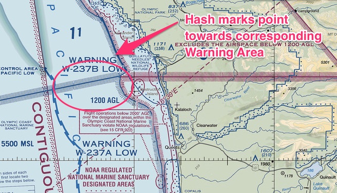
Inside the hash marks, you will see each Warning Area is named. This example below has multiple Warning Areas with their respective names.
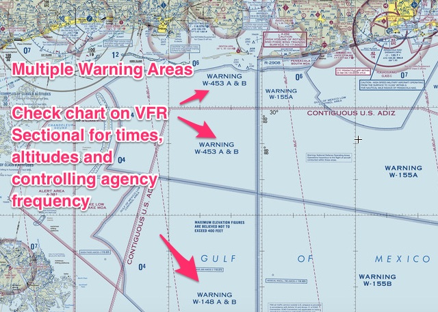
That’s it. They are pretty easy to identify. Now you know how to stay away from them! I recommend avoiding Warning Areas and Restricted Areas unless it adds a significant amount of time to your flight.
How do you know if you can fly through a Warning Area?
First, you need to determine if you can fly more than 3NM off the coast. Warning Areas are at least 3NM from the coast and sometimes much farther out. If you fly a small single engine, aircraft, are you sure you want to venture farther than 3NM and lose an engine?
If you fly an aircraft capable of overwater flight, keep reading…
Second, you need to find out if the Warning Area is open and the corresponding altitudes.
Pull out your sectional again. Locate the name of the Warning Area you wish to fly through along the coast.
Next, locate the table on the side of the VFR chart which lists all special use airspace.

Find your Warning area under the “Number” tab on the far left, then read the corresponding times and controlling agency frequency.
Warning Areas are listed after Prohibited Areas and Restricted Areas. There may be multiple tables with times and altitudes, so keep digging until you find the “W” numbers.
Notice some of them say to check NOTAMs to find out the hours? Do so, but I would definitely call FSS as well.
I wouldn’t rely solely on NOTAMs because you might miss it, but here is how you check NOTAMs for active Warning Areas.
If you have Foreflight, it’s easy. Go to the airport nearest the restricted area and under NOTAMS, click on the ARTCC button. In this example, I used Portland, OR (KPDX).
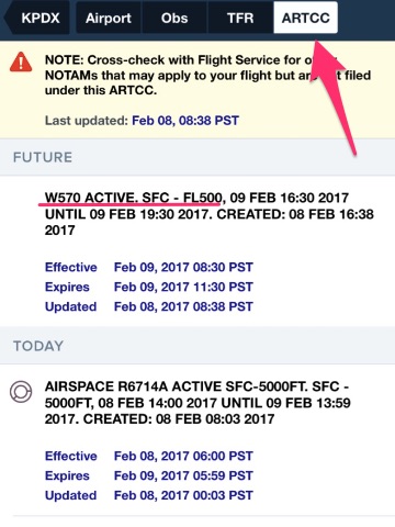
If you don’t have Foreflight, go to the FAA NOTAM website.
Click on the ARTCC section:
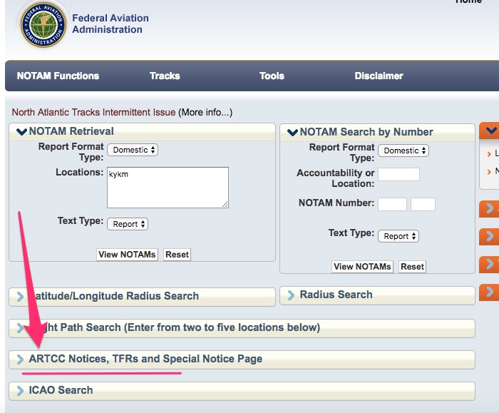
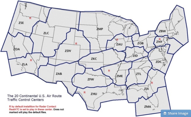
Then find your specific ARTCC area. If you don’t know it off-hand, go to this website: AirspaceCoordination.org and check out the map to find out who is your ARTCC.
For now, use this map to find the ARTCC thee-letter identifier in your area:
Then click the appropriate box on the NOTAMs page:
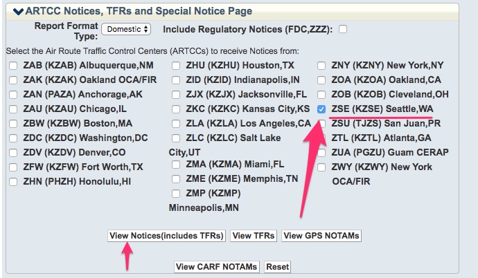
The next part is where you might miss the NOTAM for the Warning Area. There are usually a lot of ARTCC NOTAMs and you really have to dig for the one you are looking for. Check it out:

That’s it. Pretty simple, but easy to miss.
Remember, the absence of a NOTAM doesn’t mean it’s “cold” or “inactive.” Some warning areas have continuous operating times or set times and they never produce NOTAMs.
Check out this website to find out if your Warning Area is currently active or will be soon:
FAA Special Use Airspace Website
If your flight is during the closed or “cold” times, you are good, you can fly through the Warning Area. If not, fly around it. But, still check with ATC, it may be cold even if NOTAMs says it’s open or “hot.”
How do you fly through a Warning Area?
Simple: prior to entering the airspace call the controlling agency. Use the frequency you wrote down during pre-flight planning.
Confirm the airspace is cold with ATC and request permission to transit the warning area.
The airspace will either be cold or hot. You might have missed a buried NOTAM, so never enter the airspace until the controlling agency clears you.
That’s it. I hope you found this article useful. If you did, sign up below for weekly aviation tips. I don’t publish these weekly tips on my website.
You can only get them through email. Sign up below!