
This question confuses even the most experienced pilots. You are not alone.
Why do some airports have ATIS and others only have ASOS? How do you know if an airport has ASOS or AWOS? What are the different levels of ASOS and AWOS? These are all important question.
More importantly, though, how do the differences between ATIS, ASOS, and AWOS affect us as pilots?
Let’s start with the basics. I’ll explain each, then I’ll get into what it means to you.
I’m not gonna get technical because it’s not important to every day flying.
If you want more info, skip to the bottom and you’ll find more links under the section “Additional information.”
The bottom line is each of the three weather reporting systems does the same thing: they let you know what the weather is like at the airport.
The main differences are:
- whether a human is involved
- if it’s automated
- how often the reports are taken (on the hour or by the minute)
- what they report
- whether they can provide extra information like NOTAMs
- who is responsible for the systems (ie. FAA or National Weather Services)
Remember, though, all of them only report what’s going on at the airport.
If you get too far away from the reporting station you are on your own, which is why you should always check the satellite imagery between your departure and arrival airports. I’ve been caught making that mistake before and it’s not fun dealing with unexpected clouds.
What is Automated Terminal Information Service (ATIS)?
This is the gold standard because it requires a human to monitor the system. They’re more expensive you will only see these at the towered airports. When the tower closes at night, so too will the ATIS (it will revert to ASOS most likely).
To further complicate things, airports with ATIS get their information from the ASOS system. So, an airport can technically have an ATIS and an ASOS (like KPDX).
An ATIS system becomes more than just an ASOS broadcast when it adds additional information provided by a human in the tower.
Which is where the ATIS gets its name: “terminal information system.”
As you scroll down through this article you will see an image of all the ASOS stations in Oregon. Portland (KPDX) is considered an ASOS station even though it broadcasts ATIS information.
The ATIS is published hourly at 55 minutes past the hour unless the weather is changing rapidly and the tower deems it necessary to provide updated information.
Note: Some airports like Vancouver, Canada change ATIS on the hour. Most US airports change at 55 past.
It’s important you note the time when the ATIS changes, because you may want to wait a few minutes and get the most updated weather. Ground and/or tower will ask you if you have the latest ATIS.
Sometimes, on approach to the airport, the timing is such that you have to get the old ATIS knowing full well you will have to get it again. Just pick up the new ATIS when the workload decreases. Sometimes ATC will read you the info and save you from having to get it yourself.
Also, if the time on the ATIS is anything other than the standard 55 minutes past, you know the weather is changing rapidly enough the tower needed to update the weather (this is both for good and bad weather).
It doesn’t happen very often, but when I hear a report given at 2335Z, that always makes me a bit worried. But, sometimes, a change in ATIS merely a runway change. No big deal.
Every ATIS will broadcast the time in Zulu.
What does the ATIS report?
You will find ATIS at the larger more established airports (Class B and C airports and some Class D airports).
It will always give you the following information:
- Phonetic Alphabet Letter
- Time of the report in Zulu
- Landing Runway
- Wind speed and direction
- Visibility
- Cloud cover
- Temperature
- Dew Point
- Barometric pressure
- Other information (which is what makes the ATIS more thorough than a simple ASOS broadcast)
The “other information” could include information like taxiway closures, tower frequencies or anything else the tower thinks is important.
Each airport is different. For example, KPDX likes to broadcast the different frequencies for each runway even though it’s published on the approach chart.
Do not assume all of the airport’s NOTAMs are on the ATIS. Getting NOTAMs through ATIS is a terrible idea.
If an airport chooses to add NOTAMs to the ATIS, they won’t add all of them, and some airports don’t put NOTAMs in the ATIS at all.
What is Automated Surface Observing System (ASOS)?
The ASOS systems are mostly operated and controlled by the NWS, DOD and sometimes the FAA. They help the national weather system compile data on the entire United States, not just for aviation purposes.
They almost always have a basic level comparable to AWOS-III which means they can tell barometric pressure, wind speed and direction, DA, visibility, sky condition, ceiling height, and precipitation.
In other words, they are fairly robust systems and should give you enough information to make a solid choice on whether to fly.
What is Automated Weather Observing System (AWOS)?
Almost all AWOS stations are operated and controlled by the FAA. Some local state agencies will take care of them, but the DOD and NWS have no role in their operation.
These stations are automated and will report the weather every minute. This is probably the main difference between AWOS and the ASOS systems.
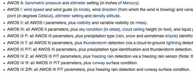
What are the different levels of AWOS?
Whew…okay this one gets complicated. I’m just gonna screenshot the information from the Wikipedia article.
I know I cut this image off a bit, but I wanted it to be readable. Go to Wikepedia if you want the list not cut off as much.
Focus on the different AWOS-3 levels because AWOS A, 1, 2 and IV stations are uncommon.
How do you know if the airport has ATIS, ASOS or AWOS?
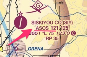
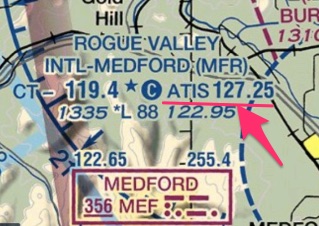
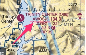
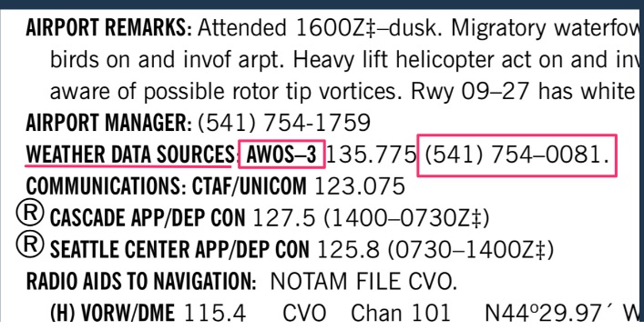
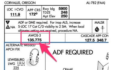
The airport diagram and approach plates will tell you which system is in use. It’s hard to tell from the METAR report as an “AUTO” in the METAR doesn’t automatically mean it’s an AWOS airport.
There are four main ways to tell what type of station is at the airport:
VFR Sectional:
Airport Diagram:

Airport Facility Directory:
Approach Plate:
Just know, however, that when the tower closes ATIS is not available. Most airports will revert to an automated system, either ASOS or AWOS.
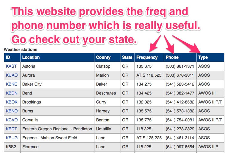
Here’s another really cool tool to see what airports have ATIS, AWOS or AWOS:
https://www.faa.gov/air_traffic/weather/asos/
Type in your state and you will see a picture like this: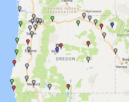
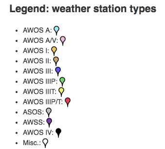
Pretty cool!!
It also will give you the frequencies and the phone numbers of the various stations in your state. Go check out your state right now! ASOS/AWOS/ATIS FAA website.
Are the ATIS or ASOS or AWOS the same as the METAR?
Yes, and no. It depends.
First: Yes, the first part of the ATIS broadcast will look exactly like the METAR. But, the METAR leaves off the information you will find on the ATIS broadcast.
The ATIS has more information than just the METAR, so while the ceiling, wind and temperature information will look the same, the ATIS will include active runways, approaches and other important information the METAR omits.
Want proof? Here is Portland’s (KPDX) ATIS vs ASOS information.
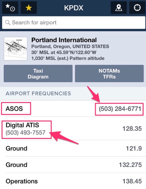
If you call the number under ASOS you will get a computer voice which reads the data identical to the METAR, however, when you call the “digital ATIS” the computer voice will carry on after the basic data and tell you what runway is in use and which approach to expect.
I can’t tell you how valuable it is to call this “digital ATIS” when you are doing flight planning (if it’s available). When you know what runway to expect, you can plan your approach into the airport.
If you struggle with figuring out how to enter the traffic pattern at an unfamiliar airport, calling the digital ATIS will let you plan it before you ever take off.
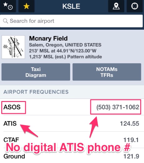
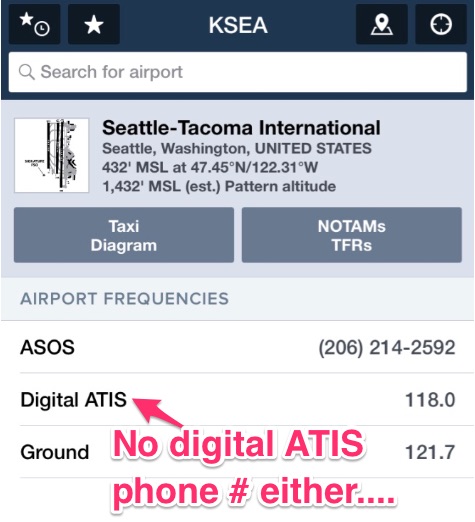
Unfortunately, not all airports have a digital ATIS phone number. I hope this changes in the future!
Look, Salem OR and even Seattle, WA, a Class B airport, doesn’t have a digital ATIS phone number.
Second: The AWOS is not the same as the METAR.
The METAR is updated every hour while the AWOS is updated every minute.
For example, take a look at Bend, OR’s airport weather. Bend has an AWOS-III station which means the weather is updated every minute. However, this is what is reported in the METAR report through Foreflight:
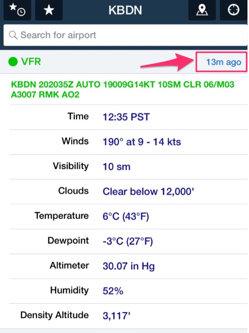
Notice the METAR was updated 13 minutes ago? So, no, the AWOS is not the same as the METAR.
To prove it, I called the AWOS number:
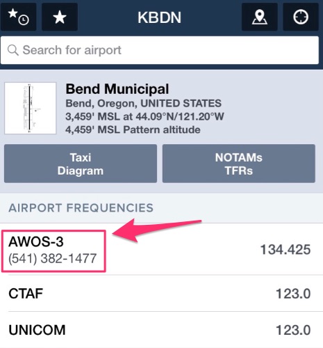
The ceilings on the METAR from 13 minutes ago said clear below 12,000,’ but when I called the AWOS number, it told me ceilings were Few at 5,500.’
I recommend you call your destination’s weather phone number when flight planning. It will give you the most updated information.
You can find the airport’s AWOS/ASOS or ATIS number in the Airport Facility Directory.

How do you tell ATC you have the weather if there is no ATIS?
The AWOS and ASOS systems don’t come with a convenient phonetic letter so you can’t let ATC know you have the weather by using a letter.
Instead, you can say: “I have the one-minute weather,” or “I have the weather at KXXX (insert your airport).”
I personally say I have the “one-minute weather.” It really doesn’t matter, they just want to know you did your homework so they don’t have to give it to you.
Some areas of the country don’t use the “one-minute weather” terminology. Just listen to what other pilots are saying and stick to that format.
Additional Information
Everything you ever wanted to know about ASOS from NOAA (PDF)
Automated airport weather stations-Wikipedia- this has all the pictures you could ever want to see of ASOS and AWOS stations.
FAA website which lets you know what airports have ATIS, ASOS or AWOS.